
Alligator Lake
Alligator Lake in the southern Yukon (near Whitehorse) lies within the overlapping traditional territories of Kwanlin Dün First Nation and Carcross/Tagish First Nation. The region is part of the broader southern Yukon cultural landscape and has long been used for hunting (especially caribou and sheep), travel, and cultural practices stretching back thousands of years. This project uses UAV photogrammetry to digitally document this unique landscape.
Region:
Yukon
Field Documentation:
July 31, 2021
Field Documentation Type:
Photogrammetry
Historic Period:
2021CE
Latitude:
60.384028
Longitude:
-135.353133
Threat Level

Alligator Lake

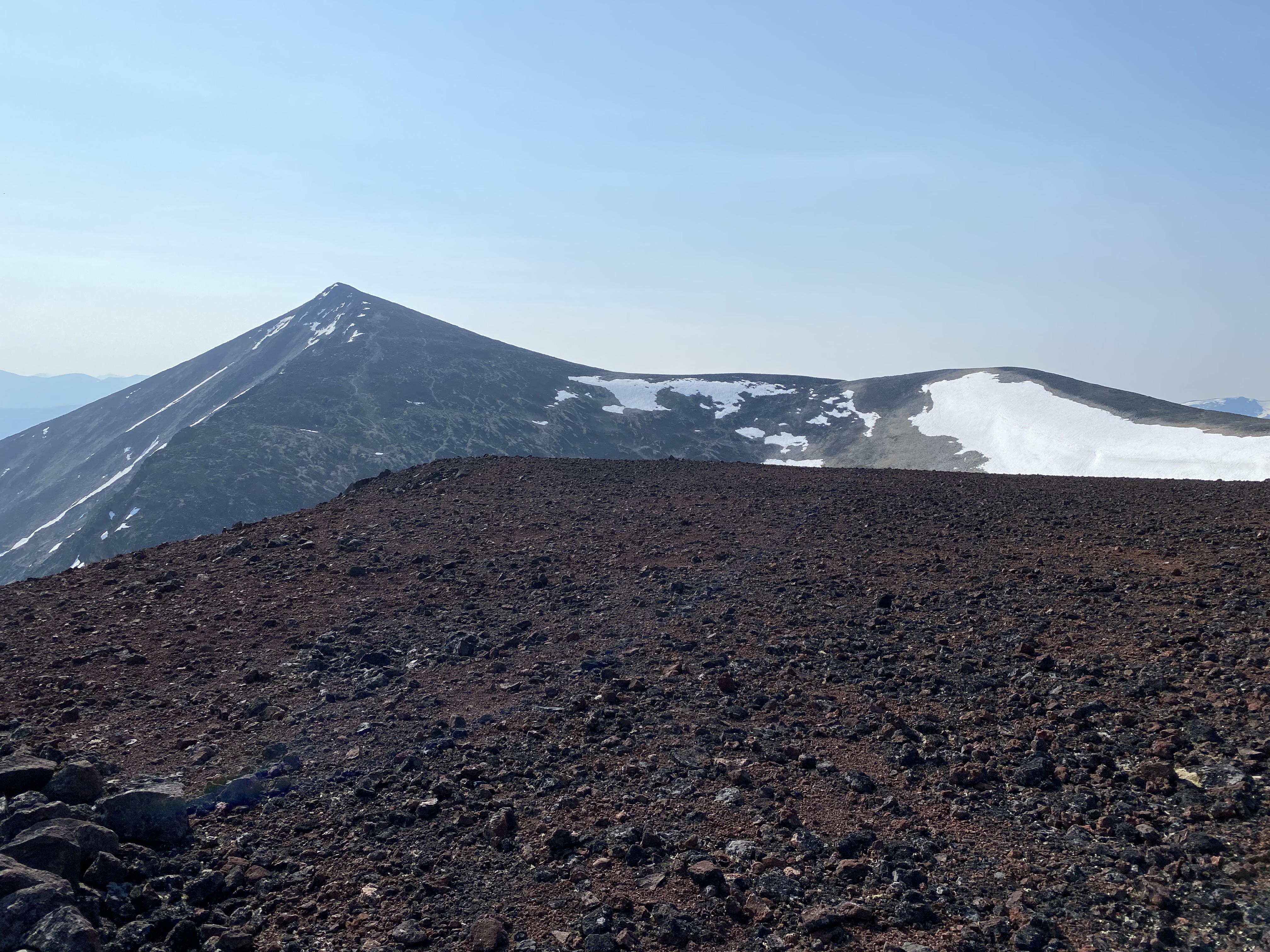
Alligator Lake is located in the mountains of southern Yukon, approximately 40 km southwest of Whitehorse. The lake lies within the traditional territories of the Carcross/Tagish First Nation and the Kwanlin Dün First Nation and forms part of a culturally significant alpine landscape that has supported Indigenous hunting and seasonal travel for thousands of years. The surrounding mountains, ice patches, and valleys preserve evidence of long-term relationships between people, animals, and the land [1,2]. This project focuses on digitally documenting the alpine landscape above Alligator Lake using UAV photogrammetry. By recording the terrain, ice patches, and archaeological features in high resolution, the project helps capture an important hunting landscape that is increasingly vulnerable to environmental change and human impact.
Archaeology Background and the Ice Patches
The alpine terrain surrounding Alligator Lake has long been an important hunting area. During the summer months, animals such as caribou and sheep gather on alpine ice patches and snowfields to escape insects and heat. Because these movements are seasonal and predictable, these locations became strategic hunting areas for Indigenous hunters [1,2]. Archaeological research has identified features associated with these hunting practices, including stone hunting blinds and lookout points positioned near ice patches. Alligator Lake likely served as a staging area for these activities, where hunters camped near the lake before travelling into the surrounding mountains to intercept animals gathering on the ice [2].
Melting alpine ice patches have revealed important archaeological discoveries in the Alligator Lake region. In 2018, a remarkably well-preserved wooden throwing dart was recovered from a nearby ice patch. Radiocarbon dating shows that the artifact is approximately 6,000 years old, demonstrating the long history of hunting in this alpine environment [2]. Organic artifacts such as wooden weapons rarely survive in most archaeological contexts, but ice patches can preserve them for thousands of years. As these ice patches melt due to climate change, artifacts that have remained frozen for millennia are emerging from the ice, important for their remarkable preservation and for demonstrating the longevity of hunting practices on these landscapes [2].
Why Digitally Capture?

The alpine landscape surrounding Alligator Lake is increasingly vulnerable to change. Climate warming is rapidly melting alpine ice patches, exposing fragile archaeological materials that were previously preserved in ice for thousands of years [2,3]. At the same time, increased recreational activity, including ATV use and mountain biking, has the potential to impact fragile archaeological features such as hunting blinds and artifact locations.
In 2021, the alpine areas surrounding Alligator Lake were digitally documented using UAV photogrammetry with a senseFly eBee Geo drone. The survey produced high-resolution imagery and a detailed 3D model of the mountaintop landscape, including ice patch areas, hunting blind features, and surrounding terrain. The resulting model shows well-established wildlife trails crossing the alpine slopes and connecting the ice patches where animals gather during the summer months. These trails reflect long-term patterns of animal movement that hunters historically relied upon when travelling from camps near Alligator Lake to hunting locations in the uplands. By digitally documenting these landscapes, the project records not only archaeological sites but also the environmental relationships that connect animal behaviour, hunting practices, and alpine terrain.
Notes:
[1] Andrews, T. D., MacKay, G., & Andrew, L. (2012). Archaeological investigations of alpine ice patches in the Selwyn Mountains, Northwest Territories, Canada. Arctic, 65(Supplement 1), 136–152.
[2] Thomas, C. D., Monahan, V., Alix, C., Hare, P. G., Herkes, J., Smith, H., Helwig, K., Poulin, J., & Donohoe, M. (2024). The Alligator Lake Throwing Dart, Yukon, Canada. Journal of Glacial Archaeology, 7, 25–45
[3] ESRI StoryMaps. (2022). Alligator Lake Geological StoryMap.
https://storymaps.arcgis.com/stories/9f662a6ee71746ef86b22c75f7de3cda
This photo gallery contains images taken during digital documentation of the Alligator Lake ice patch complex.


The Alligator Lake data set is not currently open source. Please contact Peter Dawson (pcdawson@ucalgary.ca) for more information.
Digitally Twinning a Mountain Top
A senseFly eBee Geo Drone was used to create a digital twin of the mountain top and ice patches above Alligator Lake. The digital twin is made from 1603 individual images captured by the drone on a preset flight path, covering an area of more than 2.2 square kilometers (548 acres). The flight was made challenging by the mountainous landscape. As the eBee Geo lands like a plane rather than a helicopter, the sharp rock surface atop the plateau required that the drone be caught in midair, rather than risking damage resulting from a standard landing.
Scan Locations

